


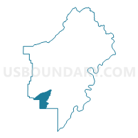
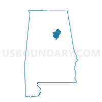
Prescott Community Center, St. Clair County, Alabama
About
Outline

Summary
| Unique Area Identifier | 522875 |
| Name | Prescott Community Center |
| County | St. Clair County |
| State | Alabama |
| Area (square miles) | 16.81 |
| Land Area (square miles) | 16.69 |
| Water Area (square miles) | 0.12 |
| % of Land Area | 99.29 |
| % of Water Area | 0.71 |
| Latitude of the Internal Point | 33.54852550 |
| Longtitude of the Internal Point | -86.45721420 |
Maps

Graphs
Select a template below for downloading or customizing gragh for Prescott Community Center, St. Clair County, Alabama


Neighbors
Neighoring Voting District (by Name) Neighboring Voting District on the Map
- Cook Springs Fire Dept., St. Clair County, AL
- Dunnavant Community Center, Shelby County, AL
- Leeds Civic Center, Jefferson County, AL
- Leeds First United Methodist Church, Jefferson County, AL
- Moody Civic Center, St. Clair County, AL
- Vandiver Volunteer Fire Department, Shelby County, AL
- Wolf Creek Fire Dept., St. Clair County, AL
Top 10 Neighboring County Subdivision (by Population) Neighboring County Subdivision on the Map
- Chelsea CCD, Shelby County, AL (35,970)
- Moody CCD, St. Clair County, AL (25,023)
- Leeds CCD, Jefferson County, AL (15,558)
Top 10 Neighboring Place (by Population) Neighboring Place on the Map
Top 10 Neighboring Unified School District (by Population) Neighboring Unified School District on the Map
- Shelby County School District, AL (170,473)
- St. Clair County School District, AL (53,540)
- Pell City City School District, AL (27,712)
- Leeds City School District, AL (11,773)
Top 10 Neighboring State Legislative District Lower Chamber (by Population) Neighboring State Legislative District Lower Chamber on the Map
- State House District 50, AL (55,378)
- State House District 48, AL (54,047)
- State House District 45, AL (42,890)
Top 10 Neighboring State Legislative District Upper Chamber (by Population) Neighboring State Legislative District Upper Chamber on the Map
- State Senate District 15, AL (160,461)
- State Senate District 17, AL (157,178)
- State Senate District 12, AL (142,431)
Top 10 Neighboring 111th Congressional District (by Population) Neighboring 111th Congressional District on the Map
Top 10 Neighboring Census Tract (by Population) Neighboring Census Tract on the Map
- Census Tract 401.06, St. Clair County, AL (6,664)
- Census Tract 110.01, Jefferson County, AL (5,663)
- Census Tract 401.05, St. Clair County, AL (4,372)
- Census Tract 309, Shelby County, AL (2,747)